A team of researchers at NASA’s Goddard Space Flight Center (GSFC) has developed a new instrument designed to eliminate blind spots between lines of lidar data on the Earth’s surface. Built with support from NASA’s Earth Science Technology Office (ESTO), the Concurrent Artificially-intelligent Spectrometry Lidar System (CASALS) could help researchers map the features of Earth’s surface with unprecedented detail. From orbit, today’s space-based laser instruments measure Earth’s forests and terrain one narrow line at a time. Between those lines are enormous gaps that include millions of acres of land scientists never directly measure. NASA’s CASALS instrument will blend machine learning with an ultra-compact lidar instrument to adaptively sweep large swaths of Earth’s surface.
How does CASALS steer light without moving parts?
Rather than mechanically steering a laser with moving mirrors, CASALS steers light using wavelength itself, generating a continuous, 3D swath of the ground below. John Yorks, a physical research scientist at GSFC and Principal Investigator for CASALS, explained that the instrument features a novel transmitter and optical grating system that manipulates laser pulses without heavy, failure-prone motorized mirrors. Instead, CASALS uses a fast-pulsing, tunable seed laser centered at 1040 nanometers, rapidly cycling through 256 unique wavelengths as it pulses through an optical component with a microscopic pattern of ridges called a transmission grating.
At this point, the physics of diffraction takes over. Because light bends at slightly different angles depending on its exact wavelength, the grating naturally steers each of the 256 pulses into a distinct position across the flight path. This non-mechanical approach paints a continuous 3D swath of the ground. Not only does this eliminate the large unmapped gaps left between the isolated tracks of legacy spaceborne lidars, but stripping away moving parts drastically reduces the instrument’s size, weight, and power requirements, making it more reliable for the harsh environment of space.
High efficiency and airborne testing results
Another key innovation within CASALS is its detector array. This component features a uniquely high Quantum Efficiency, a variable that describes how effectively a detector converts incoming light into an electrical signal. CASALS operates at 80% Quantum Efficiency, meaning it wastes almost none of the light that makes it back to the sensor. With Quantum Efficiency that high, CASALS can detect much weaker return signals, allowing it to collect useful measurements from darker surfaces or through denser vegetation.
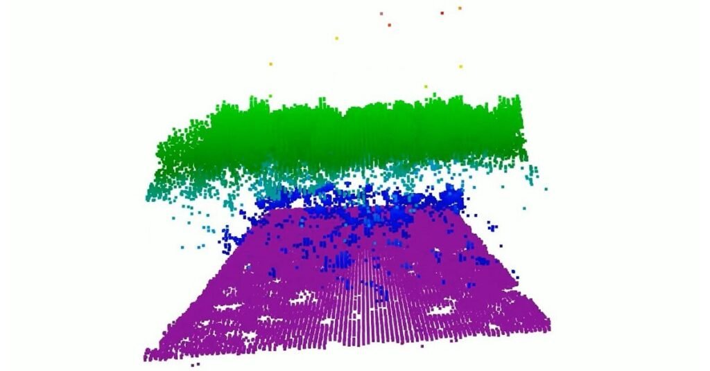
In November 2024, an airborne CASALS prototype flew aboard NASA’s B200 King Air aircraft. A video from a CASALS flight over the Great Cypress Swamp in Delaware on Nov. 12, 2024, showed tree canopy tops in green, the ground in purple, and near-ground vegetation in blue. The instrument produced science-quality datasets on its first campaign, exceeding the team’s expectations.
“I’m very impressed with Guang Yang, Jeffrey Chen, and all our engineers, and how well CASALS performed. This worked really well from the first time we flew it, which is pretty impressive,” said Yorks. Flying at an altitude of roughly five kilometers, CASALS can distinguish individual tree branches and subtle changes in ground elevation, thanks to its 22-centimeter horizontal resolution.
“We’re able to see really fine details of vegetation structure and changes in the topography of the surface,” Yorks said. The team aims to fly CASALS again as part of the Airborne Surface, Cryosphere, Ecosystem, and Nearshore Topography campaign, scheduled for summer 2027. Before creating a space-ready prototype, the team plans to make several improvements, specifically widening the instrument’s swath and adding onboard data processing software.