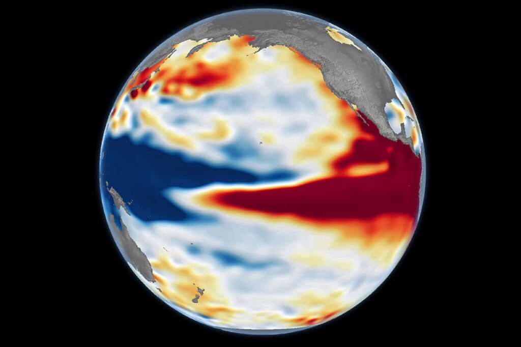
Sea levels across the central and eastern equatorial Pacific are currently higher than normal, a hallmark of El Niño. According to data from October 12, 2026, the current pattern closely resembles conditions observed on October 13, 1997, during one of the strongest El Niño events recorded by satellite altimetry.
El Niño is a natural climate pattern occurring every two to seven years that brings warmer-than-normal water to parts of the equatorial Pacific. Previous strong events, such as those in 1997-98 and 2015-16, caused global disruptions, including fires in Indonesia and the Amazon, drought-related crop failures in southern Africa, and flooding in Southern California.
The phenomenon develops through a feedback loop between the ocean and the atmosphere. Trade winds typically push warm water toward the western Pacific, but when these winds weaken, the warm water pulses eastward. This cycle can intensify as the water warms and accumulates in the central and eastern Pacific.
“The search for the ‘typical’ El Niño is very elusive,” said Josh Willis, project scientist for sea level missions at NASA’s Jet Propulsion Laboratory (JPL). “They’re all different in terms of where they land and how their impacts play out.”
Altimetry satellites measure sea surface height to track these changes, as water expands when it warms. Data from the Sentinel-6 Michael Freilich satellite, compared against historical records from the TOPEX/Poseidon mission, shows that the 2026 event developed more suddenly than the 1997-98 event. However, the current tilt of sea levels and the presence of warm water extending to South America suggest similar potential impacts.
The 2015-16 El Niño also featured elevated sea levels, but its pattern differed from 1997 and 2026. In 2015, less warm water reached the South American coast, shifting rainfall impacts toward Central America and the southeastern United States.
As of October 8, 2026, the National Oceanic and Atmospheric Administration (NOAA) projected an 83 percent chance of a strong-to-very strong El Niño through the first three months of 2027. Despite the similarities to 1997, experts caution that atmospheric conditions remain unpredictable.
“There’s always a bit of a dice roll here,” Willis said. “Just because this El Niño looks like 1997 doesn’t mean it will be exactly the same—it’s just our best guess at the moment.”