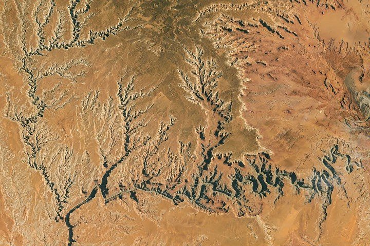
An astronaut aboard the International Space Station photographed the desert topography of Utah’s Goosenecks on October 6, 2026. The San Juan River, which flows through the area on its westward path to Lake Powell, features a series of entrenched meanders known as “goosenecks.” Within Goosenecks State Park, the river carves through a canyon 1,000 feet (300 meters) deep, creating horseshoe-shaped bends where the river travels 5.5 miles (8.9 kilometers) between two points that are only 1.3 miles (2.1 kilometers) apart.
Geologic history of the San Juan River
Tens of millions of years ago, the San Juan River flowed across a relatively flat plain formed in an ancient marine environment. Geologic forces later pushed the Colorado Plateau upward, an event some experts believe began around 20 million years ago. This elevation increased the river’s gradient and flow speed, intensifying its erosive power and allowing it to carve deep into 300-million-year-old rock.
Dark sky designation
Beyond its geologic features, the park is recognized for its dark skies, earning an International Dark Sky Park designation in 2021 due to its remote, high-desert location and 360-degree views. According to DarkSky International, celestial features such as the Double Cluster in Perseus and the Messier 24 star cloud are visible to the unaided eye. In November 2026, the park is expected to offer views of the Northern Taurids, Southern Taurids, and Leonids meteor showers.
Image acquisition details
The photograph, designated ISS075-E-188830, was captured by an Expedition 75 crew member using a Nikon Z9 digital camera with a 400-millimeter focal length. The image was provided by the ISS Crew Earth Observations Facility and the Earth Science and Remote Sensing Unit at NASA Johnson Space Center. The provided version of the photograph has been cropped and enhanced to improve contrast, with lens artifacts removed.